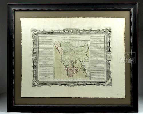
Framed 18th C. French Map of Ancient Rome
Lot 275
About Seller
Artemis Gallery
686 S Taylor Ave, Ste 106
Louisville, CO 80027
United States
Selling antiquities, ancient and ethnographic art online since 1993, Artemis Gallery specializes in Classical Antiquities (Egyptian, Greek, Roman, Near Eastern), Asian, Pre-Columbian, African / Tribal / Oceanographic art. Our extensive inventory includes pottery, stone, metal, wood, glass and textil...Read more
Estimate:
$400 - $800
Absentee vs Live bid
Two ways to bid:
- Leave a max absentee bid and the platform will bid on your behalf up to your maximum bid during the live auction.
- Bid live during the auction and your bids will be submitted real-time to the auctioneer.
Bid Increments
| Price | Bid Increment |
|---|---|
| $0 | $25 |
| $300 | $50 |
| $1,000 | $100 |
| $2,000 | $250 |
| $5,000 | $500 |
| $10,000 | $1,000 |
| $20,000 | $2,500 |
| $50,000 | $5,000 |
| $100,000 | $10,000 |
| $200,000 | $20,000 |
About Auction
By Artemis Gallery
Dec 20, 2018
Set Reminder
2018-12-20 10:00:00
2018-12-20 10:00:00
America/New_York
Bidsquare
Bidsquare : Warehouse Clear Out - Ancient & Ethnographic
https://www.bidsquare.com/auctions/artemis-gallery/warehouse-clear-out---ancient-ethnographic-3742
Time to clear out the warehouse, as these lots are going, going, gone... plus a we've added a nice selection of lots brand-new to auction! Artemis Gallery info@artemisgallery.com
Time to clear out the warehouse, as these lots are going, going, gone... plus a we've added a nice selection of lots brand-new to auction! Artemis Gallery info@artemisgallery.com
- Lot Description
**First Time At Auction**
Louis Brion de la Tour (French, 1743-1810) & Louis Charles Desnos (French, 1725-1805), "Suite De L'Histoire De Rome", ca. 1760 to 1770. Copperplate engraved with original hand color in outline and columns of text detailing each year from 3824 to 3837 (indicating years of the world) to either side of the image. An antique map of the ancient Roman Empire by a French geographer and demographer named Louis Brion de la Tour whose official title was "Geographer Engineer of the King." His maps were done in collaboration with Louis Charles Desnos (ca. 1750-1790) - Royal Globemaker to the King of Denmark, Christian VII. This map was published in "Atlas Methodique et Elementaire de Geographie et l'Histoire …" (Claude Buy de Mornas). In addition to the beautiful map and fascinating text (all in French), the map is surrounded by an elaborate decorative border that includes images of a globe, a map, and instruments of cartography as well as festoons of flowering branches and a mythical visage at top center. Size: 27.75" W x 20.5" H (70.5 cm x 52.1 cm); 34.75" W x 28.25" H (88.3 cm x 71.8 cm) including framing
Note: "Brion 1762" (referring to Louis Brion de la Tour and the year) is handwritten in pencil on lower right.
Provenance: private East Coast, USA collection
All items legal to buy/sell under U.S. Statute covering cultural patrimony Code 2600, CHAPTER 14, and are guaranteed to be as described or your money back.
A Certificate of Authenticity will accompany all winning bids.
We ship worldwide and handle all shipping in-house for your convenience.
#139773Custom framed under glass. This map has not been examined outside the frame; however, it appears to be in very good condition with a strong plate mark. Normal toning to paper with some creasing. Stains in margin - particularly on the right margin. Custom framing is excellent.Condition
- Shipping Info
-
All shipping is handled in-house for your convenience. Your invoice from Artemis Gallery will include shipping calculation instructions. If in doubt, please inquire BEFORE bidding for estimated shipping costs for individual items.
-
- Buyer's Premium


 EUR
EUR CAD
CAD AUD
AUD GBP
GBP MXN
MXN HKD
HKD CNY
CNY MYR
MYR SEK
SEK SGD
SGD CHF
CHF THB
THB


