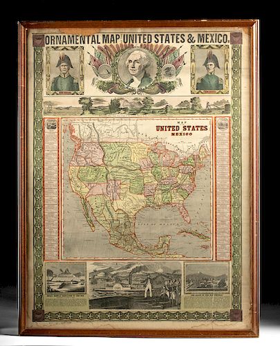
Framed 1848 United States & Mexico Map Ensigns & Thayer
Lot 177
About Seller
Artemis Gallery
686 S Taylor Ave, Ste 106
Louisville, CO 80027
United States
Selling antiquities, ancient and ethnographic art online since 1993, Artemis Gallery specializes in Classical Antiquities (Egyptian, Greek, Roman, Near Eastern), Asian, Pre-Columbian, African / Tribal / Oceanographic art. Our extensive inventory includes pottery, stone, metal, wood, glass and textil...Read more
Estimate:
$700 - $1,000
Absentee vs Live bid
Two ways to bid:
- Leave a max absentee bid and the platform will bid on your behalf up to your maximum bid during the live auction.
- Bid live during the auction and your bids will be submitted real-time to the auctioneer.
Bid Increments
| Price | Bid Increment |
|---|---|
| $0 | $25 |
| $300 | $50 |
| $1,000 | $100 |
| $2,000 | $250 |
| $5,000 | $500 |
| $10,000 | $1,000 |
| $20,000 | $2,500 |
| $50,000 | $5,000 |
| $100,000 | $10,000 |
| $200,000 | $20,000 |
About Auction
By Artemis Gallery
Nov 14, 2019
Set Reminder
2019-11-14 10:00:00
2019-11-14 10:00:00
America/New_York
Bidsquare
Bidsquare : Ethnographic | Tribal | American Frontier
https://www.bidsquare.com/auctions/artemis-gallery/ethnographic-tribal-american-frontier-4634
Featuring Pre-Columbian, Tribal / Oceanic, Spanish Colonial, historical examples from the Spanish, Mexican, and American frontiers, fossils, and more. All items offered for sale have been legally acquired, are legal to sell and are guaranteed to be as described or your money back. Artemis Gallery info@artemisgallery.com
Featuring Pre-Columbian, Tribal / Oceanic, Spanish Colonial, historical examples from the Spanish, Mexican, and American frontiers, fossils, and more. All items offered for sale have been legally acquired, are legal to sell and are guaranteed to be as described or your money back. Artemis Gallery info@artemisgallery.com
- Lot Description
North America, made in New York, USA by Ensigns & Thayer, ca. 1848 CE. A colorful printed map, "Ornamental Map of the United States & Mexico", depicting the brief moment in US history when the Mexican-American War had just concluded, defining the southern border, but much of the interior west remained populated by its original Native American inhabitants. Gold rushes and the Transcontinental Railroad would soon make the US map much more familiar to modern viewers, but here many of the details remain nebulous, though they are well-rendered by the mapmakers with nice coloration and clear print. Portraits of Washington and two generals from the Mexican-American War are at the top; below that is an imagined view of the Oregon coast. At the bottom is an imagined drawing of Tenochtitlan, the Aztec capital, along with a history of the Spanish conquest. The map comes in a nice wooden frame from the 20th century. Size in frame: 24" W x 29.5" H (61 cm x 74.9 cm)
Provenance: private Glorieta, New Mexico, USA collection
All items legal to buy/sell under U.S. Statute covering cultural patrimony Code 2600, CHAPTER 14, and are guaranteed to be as described or your money back.
A Certificate of Authenticity will accompany all winning bids.
We ship worldwide and handle all shipping in-house for your convenience.
#149455Small losses from edges, notably upper edge. Small tears at edges, notably one of the lower sides. Small stains, mainly around edges. The map itself is in great condition. Details are not lost as a result of either of these conditions. Fading to the original print. Frame is later 20th century CE and has some small chips to the wood.Condition
- Shipping Info
-
All shipping is handled in-house for your convenience. Your invoice from Artemis Gallery will include shipping calculation instructions. If in doubt, please inquire BEFORE bidding for estimated shipping costs for individual items.
-
- Buyer's Premium


 EUR
EUR CAD
CAD AUD
AUD GBP
GBP MXN
MXN HKD
HKD CNY
CNY MYR
MYR SEK
SEK SGD
SGD CHF
CHF THB
THB


