19th C. European Maps - Austria, Saxony, Holland
Lot 293
About Seller
Artemis Gallery
686 S Taylor Ave, Ste 106
Louisville, CO 80027
United States
Selling antiquities, ancient and ethnographic art online since 1993, Artemis Gallery specializes in Classical Antiquities (Egyptian, Greek, Roman, Near Eastern), Asian, Pre-Columbian, African / Tribal / Oceanographic art. Our extensive inventory includes pottery, stone, metal, wood, glass and textil...Read more
Categories
Estimate:
$550 - $825
Absentee vs Live bid
Two ways to bid:
- Leave a max absentee bid and the platform will bid on your behalf up to your maximum bid during the live auction.
- Bid live during the auction and your bids will be submitted real-time to the auctioneer.
Bid Increments
| Price | Bid Increment |
|---|---|
| $0 | $25 |
| $300 | $50 |
| $1,000 | $100 |
| $2,000 | $250 |
| $5,000 | $500 |
| $10,000 | $1,000 |
| $20,000 | $2,500 |
| $50,000 | $5,000 |
| $100,000 | $10,000 |
| $200,000 | $20,000 |
About Auction
By Artemis Gallery
Oct 14, 2021
Set Reminder
2021-10-14 10:00:00
2021-10-14 10:00:00
America/New_York
Bidsquare
Bidsquare : CLEARANCE | Ancient & Ethnographic Art
https://www.bidsquare.com/auctions/artemis-gallery/clearance-ancient-ethnographic-art-7705
Kick off fall with our clearance sale featuring discounted pricing and many new items! Asian art, Classical antiquities from Egypt, Greece, Italy, and the Near East...plus Pre-Columbian, Tribal, Russian Icons & Enamelware, Spanish Colonial, Fine Art, Fossils, more! Starting prices have been reduced Artemis Gallery info@artemisgallery.com
Kick off fall with our clearance sale featuring discounted pricing and many new items! Asian art, Classical antiquities from Egypt, Greece, Italy, and the Near East...plus Pre-Columbian, Tribal, Russian Icons & Enamelware, Spanish Colonial, Fine Art, Fossils, more! Starting prices have been reduced Artemis Gallery info@artemisgallery.com
- Lot Description
**Originally Listed At $300**
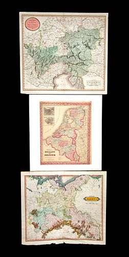
THREE ANTIQUE EUROPEAN MAPS including: (1) John Cary (British, 1754-1835). "A New Map of the Circle of Austria, from the Latest Authorities." London, 1801. An attractive 1801 map of Austria by British cartographer and publisher John Cary delineated with impressive detail and nice coloring to indicate regions, created for John Cary's 1808 "New Universal Atlas". Cary was praised for his signature style which greatly influenced others in the map industry as well as his very clean engraving technique. Size of Cary map including margins: 9.3" L x 21.3" W (49 cm x 54.1 cm)
(2) William Home Lizars (Scottish, 1788-1859). "Upper Saxony Partly belonging to Prussia." Published in Edinburgh by D. Lizars. A double page hand-colored, engraved map to accompany Lizars' Edinburgh Geographical General Atlas (1841) with relief delineated in hachures and identifications of towns, rivers, roads, mountains, and forests. Size: 18.875" L x 21.625" W (47.9 cm x 54.9 cm)
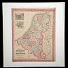
(3) Joseph Hutchins Colton (American, 1800-1893). "Colton's Holland and Belgium" - map is dated 1855 and has a handwritten note "au 1862" on lower left. Published from Colton's New York City office (172 William Street) as plate no. 10 in Colton's "Atlas of the World". An antique map of Holland and Belgium identifying towns, cities, villages, rivers, canals, railroads, roads and more. Note that the provinces in Holland and Belgium are nicely colored, and the entire map is surrounded by an attractive decorative border. Approximate size not including matte: 15.875" L x 12.75" W (40.3 cm x 32.4 cm)
Provenance: private Lucille Lucas collection, Crested Butte, Colorado, USA
All items legal to buy/sell under U.S. Statute covering cultural patrimony Code 2600, CHAPTER 14, and are guaranteed to be as described or your money back.
A Certificate of Authenticity will accompany all winning bids.
PLEASE NOTE: Due to recent increases of shipments being seized by Australian & German customs (even for items with pre-UNESCO provenance), we will no longer ship most antiquities and ancient Chinese art to Australia & Germany. For categories of items that are acceptable to ship to Australia or Germany, please contact us directly or work with your local customs brokerage firm.
Display stands not described as included/custom in the item description are for photography purposes only and will not be included with the item upon shipping.
#134338Cary's "A New Map of the Circle of Austria, from the Latest Authorities" has slight toning, a few handwritten notes in margins, visible centerfold, minor nicks/tears to peripheries, and one piece of tape on verso. Otherwise, the imagery, text, and hand coloring are very strong. "Upper Saxony Partly belonging to Prussia" shows slight toning, a faint handwritten note on lower right margin, a visible centerfold, 2 inch separation to lower end of centerfold, and nicks/tears/losses to peripheries. Otherwise, imagery, text, and hand coloring are very strong. "Colton's Holland and Belgium" is laid to the matte. Appears to have a couple of tears to lower right, minor loss to upper right edge, and repair to upper left corner. When held to the light one can see expected losses/tears to peripheries that are hidden by the matte. "au 1862" is handwritten in pencil at lower left but printed date of 1855 at lower end of map. Paper shows normal toning and a few minor stains. Imagery, text, and coloring are vivid.Condition
- Shipping Info
-
All shipping is handled in-house for your convenience. Your invoice from Artemis Gallery will include shipping calculation instructions. If in doubt, please inquire BEFORE bidding for estimated shipping costs for individual items.
-
- Buyer's Premium


 EUR
EUR CAD
CAD AUD
AUD GBP
GBP MXN
MXN HKD
HKD CNY
CNY MYR
MYR SEK
SEK SGD
SGD CHF
CHF THB
THB


