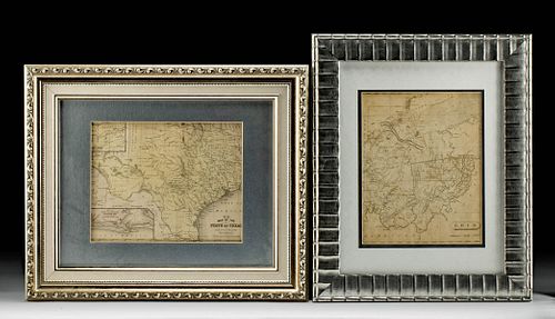
19th C. American Maps of Ohio and Texas
Lot 344
About Seller
Artemis Fine Arts
686 S Taylor Ave, Ste 106
Louisville, CO 80027
United States
Selling antiquities, ancient and ethnographic art online since 1993, Artemis Gallery specializes in Classical Antiquities (Egyptian, Greek, Roman, Near Eastern), Asian, Pre-Columbian, African / Tribal / Oceanographic art. Our extensive inventory includes pottery, stone, metal, wood, glass and textil...Read more
Categories
Estimate:
$800 - $1,200
Absentee vs Live bid
Two ways to bid:
- Leave a max absentee bid and the platform will bid on your behalf up to your maximum bid during the live auction.
- Bid live during the auction and your bids will be submitted real-time to the auctioneer.
Bid Increments
| Price | Bid Increment |
|---|---|
| $0 | $25 |
| $300 | $50 |
| $1,000 | $100 |
| $2,000 | $250 |
| $5,000 | $500 |
| $10,000 | $1,000 |
| $20,000 | $2,500 |
| $50,000 | $5,000 |
| $100,000 | $10,000 |
| $200,000 | $20,000 |
About Auction
By Artemis Fine Arts
Jun 17, 2021
Set Reminder
2021-06-17 10:00:00
2021-06-17 10:00:00
America/New_York
Bidsquare
Bidsquare : Ancient & Ethnographic Art Through The Ages
https://www.bidsquare.com/auctions/artemis-gallery/ancient-ethnographic-art-through-the-ages-7094
Ancient art from Egypt, Greece, Italy and the Near East, as well as Asian, Fossils, Pre-Columbian, Native American, African / Tribal / Oceanic, Fine art, and much more! All categories, all price ranges... all legally acquired and guaranteed to be as described or your money back. Artemis Fine Arts info@artemisgallery.com
Ancient art from Egypt, Greece, Italy and the Near East, as well as Asian, Fossils, Pre-Columbian, Native American, African / Tribal / Oceanic, Fine art, and much more! All categories, all price ranges... all legally acquired and guaranteed to be as described or your money back. Artemis Fine Arts info@artemisgallery.com
- Lot Description
Samuel Augustus Mitchell (1792-1868). "No. 13 Map of the State of Texas. Engraved to illustrate Mitchell's School and Family Geography." Published 1852. Arrowsmith & Lewis. "Barker's Ohio Map." 1805. A pair of antique maps set in attractive frames. First is a map of Texas that shows roads, county lines, military posts, battlegrounds, major cities, towns, and regions inhabited by Native Americans with relief shown by hachures. It also includes insets of "Northern Texas," and "Map of the vicinity of Galveston City." Size of Texas map: 7.5" L x 9.5" W (19 cm x 24.1 cm) Size of frame: 15" L x 18" W (38.1 cm x 45.7 cm)
Next is an early 19th century map of Ohio known as "Barker's Ohio Map," dating to 1805, and among the earliest maps to depict the state of Ohio in its infancy. The map includes the roads and areas inhabited by Native Americans. The state is also divided into Army Land, Indian Land, Seven Ranges, a French grant, and a Virginia Donation. In the northwest region, one can see the statement, "Major Truman killed" highlighting where Captain Alexander Truman was killed in 1792. There is another area with a statement indicating where Indians were defeated on August 20, 1794, just south of Fort Ohio. In addition, there are several statements describing the condition of the areas, "No good landing" and "Good landing along here" for example. Size of Ohio map: 9.5" L x 7.5" W (24.1 cm x 19 cm) Size of frame: 17" L x 14" W (43.2 cm x 35.6 cm)
Provenance: ex Stein collection, Bloomfield Hills, Michigan, USA, acquired prior to 2010
All items legal to buy/sell under U.S. Statute covering cultural patrimony Code 2600, CHAPTER 14, and are guaranteed to be as described or your money back.
A Certificate of Authenticity will accompany all winning bids.
We ship worldwide and handle all shipping in-house for your convenience.
#164276Maps have not been examined outside the frames. Both appear to present with normal toning commensurate with age. Frames are excellent.Condition
- Shipping Info
-
All shipping is handled in-house for your convenience. Your invoice from Artemis Gallery will include shipping calculation instructions. If in doubt, please inquire BEFORE bidding for estimated shipping costs for individual items.
-
- Buyer's Premium


 EUR
EUR CAD
CAD AUD
AUD GBP
GBP MXN
MXN HKD
HKD CNY
CNY MYR
MYR SEK
SEK SGD
SGD CHF
CHF THB
THB


