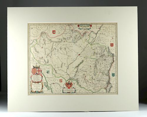
17th C. Dutch Map of the Kingdom of Aragon in N. Spain
Lot 129
About Seller
Artemis Fine Arts
686 S Taylor Ave, Ste 106
Louisville, CO 80027
United States
Selling antiquities, ancient and ethnographic art online since 1993, Artemis Gallery specializes in Classical Antiquities (Egyptian, Greek, Roman, Near Eastern), Asian, Pre-Columbian, African / Tribal / Oceanographic art. Our extensive inventory includes pottery, stone, metal, wood, glass and textil...Read more
Categories
Estimate:
$700 - $1,000
Absentee vs Live bid
Two ways to bid:
- Leave a max absentee bid and the platform will bid on your behalf up to your maximum bid during the live auction.
- Bid live during the auction and your bids will be submitted real-time to the auctioneer.
Bid Increments
| Price | Bid Increment |
|---|---|
| $0 | $25 |
| $300 | $50 |
| $1,000 | $100 |
| $2,000 | $250 |
| $5,000 | $500 |
| $10,000 | $1,000 |
| $20,000 | $2,500 |
| $50,000 | $5,000 |
| $100,000 | $10,000 |
| $200,000 | $20,000 |
About Auction
By Artemis Fine Arts
Sep 13, 2018
Set Reminder
2018-09-13 10:00:00
2018-09-13 10:00:00
America/New_York
Bidsquare
Bidsquare : Ancient | Asian | Ethnographic - Fall Variety
https://www.bidsquare.com/auctions/artemis-gallery/ancient-asian-ethnographic---fall-variety-3432
Travel the world and back in time... Antiquities from Egypt, Greece, Italy and the Near East, Asian, Pre-Columbian, African / Tribal / Oceanic, Native American, Spanish Colonial, Russian Icons, Fine Art, much more! Artemis Fine Arts info@artemisgallery.com
Travel the world and back in time... Antiquities from Egypt, Greece, Italy and the Near East, Asian, Pre-Columbian, African / Tribal / Oceanic, Native American, Spanish Colonial, Russian Icons, Fine Art, much more! Artemis Fine Arts info@artemisgallery.com
- Lot Description
Juan Bautista Labanna (also Labana; Portuguese, 1555-1624, "Arragonia Regnum", copperplate engraving with original hand coloring, ca. 1645 CE. Publisher: Joan Blaue of Amsterdam. Map of the Kingdom of Aragon in northern Spain. Relief shown pictorially. Oriented with north to the right. Dedicated to Gaspari Charles, seigneur of Baerledoncq, by William and Joan Blaeu. Text in Latin. Text on verso as well. A beautiful, highly decorative map of Aragon in Northern Spain, centered on Caragoca (Saragossa) and extending to Cuenca, Calahorra, Tortola, Lerida, and Pamplona. Towns, rivers, mountains, lakes and valleys are depicted. The map also contains two large cartouches and 5 coats of arms inland. A wonderful example of 17th century Dutch mapmaking, replete with informative details as well as sophisticated artistry. Size: map ~ 20.5" W x 16.25" H (52.1 cm x 41.3 cm); 30" W x 24" H (76.2 cm x 61 cm) with mat
Juan Bautista Labana was a very accomplished Portuguese cartographer and geographer. Born in Lisbon in 1555, he passed away in Madrid in 1624. Labana held the position of senior cosmographer of the Council of the Indies and was also the Chair of Navigation of the Academy of Mathematics of Madrid. In addition, Labana completed several studies on Naval Architecture - the design and construction of ships. Most Labana has been considered by many to be the first explorer of the Kingdom of Aragon.
Provenance: eSEx-Denenberg Fine Arts, Los Angeles, California, USA
All items legal to buy/sell under U.S. Statute covering cultural patrimony Code 2600, CHAPTER 14, and are guaranteed to be as described or your money back.
A Certificate of Authenticity will accompany all winning bids.
We ship worldwide and handle all shipping in-house for your convenience.
#136694Centerfold and creases as shown. Normal toning and foxing in areas. Imagery and text are very vivid. Expected tears and losses to edges, but the map still shows very well. Set in a white mat. Taped only at the upper edges with acid-free tape.Condition
- Shipping Info
-
All shipping is handled in-house for your convenience. Your invoice from Artemis Gallery will include shipping calculation instructions. If in doubt, please inquire BEFORE bidding for estimated shipping costs for individual items.
-
- Buyer's Premium


 EUR
EUR CAD
CAD AUD
AUD GBP
GBP MXN
MXN HKD
HKD CNY
CNY MYR
MYR SEK
SEK SGD
SGD CHF
CHF THB
THB


