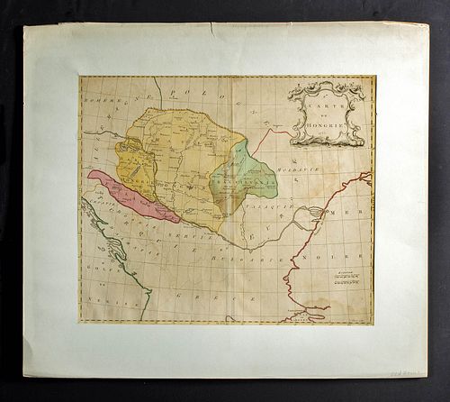
1755 Palairet Gibson Map of Hungary w/ Hand Coloring
Lot 141a
About Seller
Artemis Gallery
686 S Taylor Ave, Ste 106
Louisville, CO 80027
United States
Selling antiquities, ancient and ethnographic art online since 1993, Artemis Gallery specializes in Classical Antiquities (Egyptian, Greek, Roman, Near Eastern), Asian, Pre-Columbian, African / Tribal / Oceanographic art. Our extensive inventory includes pottery, stone, metal, wood, glass and textil...Read more
Categories
Estimate:
$300 - $400
Absentee vs Live bid
Two ways to bid:
- Leave a max absentee bid and the platform will bid on your behalf up to your maximum bid during the live auction.
- Bid live during the auction and your bids will be submitted real-time to the auctioneer.
Bid Increments
| Price | Bid Increment |
|---|---|
| $0 | $25 |
| $300 | $50 |
| $1,000 | $100 |
| $2,000 | $250 |
| $5,000 | $500 |
| $10,000 | $1,000 |
| $20,000 | $2,500 |
| $50,000 | $5,000 |
| $100,000 | $10,000 |
| $200,000 | $20,000 |
About Auction
By Artemis Gallery
Jun 24, 2021
Set Reminder
2021-06-24 10:00:00
2021-06-24 10:00:00
America/New_York
Bidsquare
Bidsquare : VARIETY SALE | Ancient & Ethnographic Art
https://www.bidsquare.com/auctions/artemis-gallery/variety-sale-ancient-ethnographic-art-7119
Featuring classical antiquities, ancient and ethnographic art. Egyptian, Greek, Roman, Etruscan, Near Eastern, Asian, Pre-Columbian, Native American, African / Tribal, Oceanic, Spanish Colonial, Russian, Fossils, Fine Art, more! All legally acquired, legal to sell. Satisfaction guaranteed. Artemis Gallery info@artemisgallery.com
Featuring classical antiquities, ancient and ethnographic art. Egyptian, Greek, Roman, Etruscan, Near Eastern, Asian, Pre-Columbian, Native American, African / Tribal, Oceanic, Spanish Colonial, Russian, Fossils, Fine Art, more! All legally acquired, legal to sell. Satisfaction guaranteed. Artemis Gallery info@artemisgallery.com
- Lot Description
Cartographer: Jean Palairet (French, 1697-1774). Engraver: John Gibson (British, active 1750-1792). Publisher: P. Gosse. "Carte de Hongrie" 1755. Place of Publication: London, England. An 18th century copperplate engraved map by French cartographer Jean Palairet published in "Atlas Methodique" (1755) in London by British cartographer John Gibson. The map is beautifully hand colored and presents with a central fold mark and a lovely cartouche adorned by a decorative border of floral and tendril motifs surrounding the title "CARTE DE HONGRIE / 1755". Size of map: 18" L x 21.5" W (45.7 cm x 54.6 cm) Size of matte: 25.75" L x 29.25" W (65.4 cm x 74.3 cm)
According to Barry Lawrence Ruderman, "Jean Palairet (1697-1774) was a mapmaker and teacher. He was born in Montauban, France, but emigrated to England as a young man. He worked as an agent for the French States General and as the French tutor to the children of George II. Later, he served as the Agent to the Dutch States-General in London. He wrote works on orthography and French grammar, as well as published a geography primer, a teaching atlas, and his more famous map of the colonies with an accompanying pamphlet."
Provenance: private Lucille Lucas collection, Crested Butte, Colorado, USA
All items legal to buy/sell under U.S. Statute covering cultural patrimony Code 2600, CHAPTER 14, and are guaranteed to be as described or your money back.
A Certificate of Authenticity will accompany all winning bids.
We ship worldwide and handle all shipping in-house for your convenience.
#134003Map is set in a matte, but could possibly be carefully removed from the matte. This said the upper section is tightly secured within. Expected toning and stains commensurate with age. Some losses to peripheries. Nice hand coloring and strong plate mark and center fold. Minor two inch separation at lower end of center fold. Faint impression of map that was on previous page of atlas is visible.Condition
- Shipping Info
-
All shipping is handled in-house for your convenience. Your invoice from Artemis Gallery will include shipping calculation instructions. If in doubt, please inquire BEFORE bidding for estimated shipping costs for individual items.
-
- Buyer's Premium


 EUR
EUR CAD
CAD AUD
AUD GBP
GBP MXN
MXN HKD
HKD CNY
CNY MYR
MYR SEK
SEK SGD
SGD CHF
CHF THB
THB


