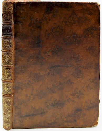
Sanson, Cartes Generales, Composite Atlas, 1658
Lot 137
About Seller
Arader Galleries
1308 Walnut Street
King of Prussia, PA 19406
United States
Arader Galleries proudly celebrates over 40 years in the business of important, antique works on paper, paintings and rare books. W. Graham Arader III began his collection of rare maps, atlases and Americana while an undergraduate at Yale University, and today that passion has grown into one of the ...Read more
Estimate:
$20,000 - $30,000
Absentee vs Live bid
Two ways to bid:
- Leave a max absentee bid and the platform will bid on your behalf up to your maximum bid during the live auction.
- Bid live during the auction and your bids will be submitted real-time to the auctioneer.
Bid Increments
| Price | Bid Increment |
|---|---|
| $0 | $25 |
| $500 | $50 |
| $1,000 | $100 |
| $2,000 | $250 |
| $5,000 | $500 |
| $10,000 | $1,000 |
| $20,000 | $2,000 |
| $50,000 | $5,000 |
| $100,000 | $10,000 |
| $200,000 | $25,000 |
About Auction
By Arader Galleries
Mar 25, 2017 - Mar 26, 2017
Set Reminder
2017-03-25 13:00:00
2017-03-26 13:00:00
America/New_York
Bidsquare
Bidsquare : Arader Galleries Spring 2017 Auction
https://www.bidsquare.com/auctions/arader/arader-galleries-spring-2017-auction-2184
Arader Galleries loricohen@aradergalleries.com
Arader Galleries loricohen@aradergalleries.com
- Lot Description
Cartes Generales de Toutes les Parties du Monde. Nicholas Sanson D'Abbeville (1600-1667). Paris: The Author and Pierre Mariette, 1658 [but 1659]. Folio. (17 x 11 6/8 inches). Title-page with woodcut arms (dampstained), 3-page contemporary manuscript "Repertoir des Cartes de ce livre" (without letterpress table of contents). 85 FINE engraved double-page maps, including 10 folding, hand-coloured in outline, mounted on guards throughout (one or two early repairs, tears, stains and edges frayed to folding map of Gascony, last map of Ancient Greece stained and laid down on contemporary stock). Contemporary mottled calf, spine in seven compartments with six raised bands, morocco lettering piece in one, the others decorated with small gilt tools (scuffed and worn with loss to extremities).. A fine composite atlas: the manuscript list of contents detailing the 75 maps of the modern world, including two world maps, with an additional ten maps of the old world, including one world map. With two maps of America: "Amerique Septentrionale" (1650), the first to show all five Great Lakes; and "Amerique Meridionale" 1650. The maps were compiled by Nicolas Sanson who first published his atlas in 1654, with 100 maps, and engraved and printed by Pierre Mariette; each held the copyright to half of the maps which bear their separate imprints, and were issued progressively from 1630. The maps in this Atlas date from 1632 "Carte Geographique des Postes qui traversent la France" by Melchior Tavernier, but are evenly dated from the late 1630s to 1659. Born in Abbeville, a town in the Picardy region of France, in 1600, Sanson was the most noted French cartographer in modern history. Mapmaker to Louis XIV, King of France, Sanson endowed his maps with the most recent geographical information as well as the finest and sharpest engraving of the period. His "Cartes Generales de Toutes les Parties du Monde" was the most important single product of French commercial cartography of the seventeenth century. Sanson sparked a renaissance in geographical endeavor in his native country, which had not been a major player on the international cartographic stage since the great Oronce Finé in the sixteenth century. With this atlas, Sanson laid the foundations of French domination in map production, initiating the so-called "French school of cartography," a school that was unprecedented in its attention to precision and scientific detail and discarded much of the decorative embellishments of previous maps as irrelevant. From Sanson's time in the second half of the seventeenth century until the latter part of the eighteenth century, French geographical conceptions were more influential than those put forward by any other nation. With this landmark atlas, Sanson all but single-handedly caused the center of cartographic innovation to shift from Holland to France. Lloyd Arnold Brown, The World Encompassed, exh. cat. (Baltimore, 1952), n. 157; Rodney W. Shirley, The Mapping of the World (London, 1983), n. 390; Philip D. Burden, The Mapping of North America: A List of Printed Maps 1511-1670 (Rickmansworth, 1996), 375-6. Guidance: Christie’s, 2010 - $47,500
- Shipping Info
-
Shipping Terms:Packing and handling of purchased lots by us or by someone else is at the entire risk of the purchaser. Purchasers are responsible for all packing and shipping costs.
We are not responsible for the acts or omissions of carriers or packers of purchased lots whether or not recommended by us.
-
- Buyer's Premium


 EUR
EUR CAD
CAD AUD
AUD GBP
GBP MXN
MXN HKD
HKD CNY
CNY MYR
MYR SEK
SEK SGD
SGD CHF
CHF THB
THB


