Menu

 EUR
EUR CAD
CAD AUD
AUD GBP
GBP MXN
MXN HKD
HKD CNY
CNY MYR
MYR SEK
SEK SGD
SGD CHF
CHF THB
THBEdwin James' description of the Expedition of Stephen Long
Lot 156
About Seller
Arader Galleries
1308 Walnut Street
King of Prussia, PA 19406
United States
Arader Galleries proudly celebrates over 40 years in the business of important, antique works on paper, paintings and rare books. W. Graham Arader III began his collection of rare maps, atlases and Americana while an undergraduate at Yale University, and today that passion has grown into one of the ...Read more
Categories
Estimate:
$12,000 - $15,000
Absentee vs Live bid
Two ways to bid:
- Leave a max absentee bid and the platform will bid on your behalf up to your maximum bid during the live auction.
- Bid live during the auction and your bids will be submitted real-time to the auctioneer.
Bid Increments
| Price | Bid Increment |
|---|---|
| $0 | $25 |
| $500 | $50 |
| $1,000 | $100 |
| $2,000 | $250 |
| $5,000 | $500 |
| $10,000 | $1,000 |
| $20,000 | $2,000 |
| $50,000 | $5,000 |
| $100,000 | $10,000 |
| $200,000 | $25,000 |
About Auction
By Arader Galleries
Nov 5, 2016 - Nov 6, 2016
Set Reminder
2016-11-05 13:00:00
2016-11-06 12:00:00
America/New_York
Bidsquare
Bidsquare : Arader Galleries Fall Auction
https://www.bidsquare.com/auctions/arader/arader-galleries-fall-auction-1872
Arader Galleries loricohen@aradergalleries.com
Arader Galleries loricohen@aradergalleries.com
- Lot Description
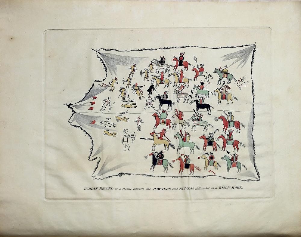
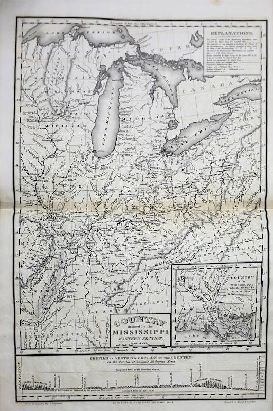
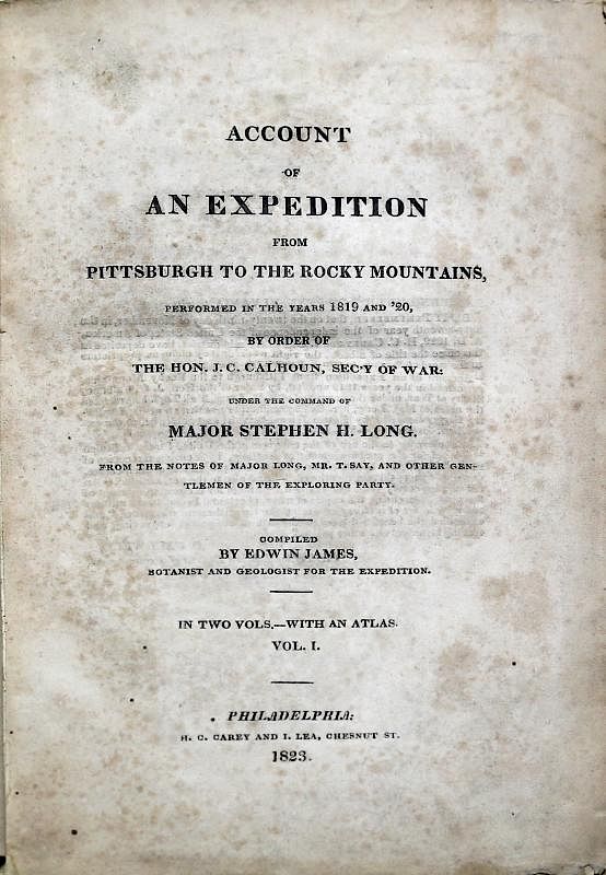
Account of an Expedition from Pittsburgh to the Rocky Mountains, performed in the years 1819, and '20, by order of The Hon. J. C. Calhoun, Sec'y of War: under the Command of Major Stephen H. Long. Edwin James (1797-1861). Philadelphia: H. C. Carey & Lea, [1822]-1823. Three volumes: two octavo text volumes (8.75 x 5.375 inches), plus one large quarto atlas volume (11.25 x 9.125 inches). Three volumes individually chemised and housed together in a quarter red morocco over maroon cloth slipcase. Slipcase spine ruled in blind and lettered in gilt with five raised bands. Text volumes: (heavy foxing throughout both text volumes, part of lower right title page missing, and foxing on engraving list, some pages loose, A few pencil markings and annotations; two words ("clitoris" and "labia") crossed out on page 187 of Volume II). Spine in 6 compartments, elaborately gilt, with black calf lettering pieces "LONG'S EXPEDITION" in one and each volume numbered in another (top cover hinge loose on both text volumes, some residue present from previous repair on volume 1, loose chip on spine of volume 2, shelf wear). Atlas volume: fold out maps with (some light foxing, short tears throughout, slight vertical crease to title leaf and "List of Engravings" leaf due to the outermost fold of the first map). Quarter calf on marbled boards (spine cracked and chipped, hinges loose, rear board loosely held). Provenance: Inscription on title page reads "John Weeks Moore Author of Moore's Encyclopedia of Music" Detailed elevation profiles on each map with very stylized depictions of mountain ranges nearly a la Tolkien. Highly annotated maps, each accompanied by keys or "Explanations" in upper right corners. All the maps and plates themselves are largely untouched by discoloration, some short superficial tears not affecting the images. First edition. One of the great expeditions to chart the vast Western United States in the tradition of Lewis and Clark. This work is key to United States history and its Westward Expansion for a number of reasons, including producing the very first image of the Rocky Mountains, and preserving in written description and stunning images, the lives and cultures of the Native American people before the advent of the white man. "The account of Long's expedition ranks alongside those of Lewis and Clark and Zebulon Pike as one of the three great classics of Western exploration. This official account was compiled by Edwin James [1797-1861], a naturalist and physician to the expedition. Major Stephen Harriman Long (1784-1864), a Dartmouth graduate and U.S. Army engineer, was sent to explore the western portions of the Louisiana Purchase and the Rocky Mountains. The expedition discovered and climbed several peaks, including Long's Peak, and explored the regions of the Platte and Arkansas River Valleys. This work, with its fine atlas, is a most valuable contribution to geographical and ethnographical literature" (Hill). "In all of Major Long's explorations, the natives of the territories through which he passed received the largest share of his attention. This will be evident from an examination of the table of contents of each volume. Chapters vi. to xii. of Vol. I. are entitled: 'Account of the Konza nation-Councils with the Otois, Missouries, Ioways, Pawnees,' &c.-Sioux & Omahaw Indians. Account of the Omahaws, Manners, Customs & Religious Rites. History of Blackbird their principal chief. Of their Marriage, Infancy & Old Age, Diseases, Medical Knowledge, Vices, Ideas of God, Superstition and expiatory Tortures. Vol. II.: The subject of Mourning for the deceased. War, Legend, and Language is pursued in chapters i. to iv. Chapter xii. An account of the Kaskasias. A great part of Volume III. is devoted to observations upon the Shienne, Arapaho, Pawnee, and other tribes of the Plains. Of the eight plates seven are illustrative of Indian life and manners" (Field 948, describing the 1823 London edition). The maps are reproduced in Wheat, Mapping the Transmississippi West, Volume II, with the concluding comment: "Long's map...represented a distinct step forward...Its use of 'Great American Desert' for the high plains country made for public apprehension over a generation...But the map cleared up a number of geographical errors...And the mid-mountain country of the easterly front wall of the Rockies was now correctly mapped from Long's Peak to the Spanish Peaks, with the country to the east correctly shown." References: Bradford 2637; Graff 2188; Hill 877; Howes J41; Pilling, Proof-sheets, 1958; Sabin 35682; Streeter 1783; Wagner-Camp-Becker 25:1; Wheat, Mapping the Transmississippi West, 353, and II, page 80. For all inquiries please contact Greg McMurray, MLS, Director, Rare Books.
- Shipping Info
-
Packing and handling of purchased lots by us or by someone else is at the entire risk of the purchaser. Purchasers are responsible for all packing and shipping costs.
We are not responsible for the acts or omissions of carriers or packers of purchased lots whether or not recommended by us.
-
- Buyer's Premium
