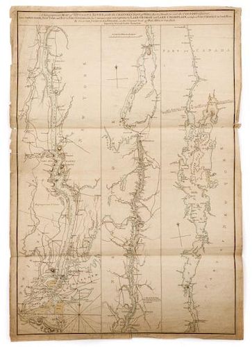
Scarce 1st St. Revolutionary War English Map Of US
Lot 272
About Seller
Ahlers & Ogletree
1788 Ellsworth Industrial Boulevard NW
Atlanta, GA 30318
United States
Ahlers & Ogletree Auction Gallery is a full-service auction gallery strategically located on Miami Circle in the historic Buckhead district of Atlanta, one of the Southeastern United States’ largest commercial and financial centers. The gallery is owned and operated by Robert Ahlers and his wife Chr...Read more
Categories
Estimate:
$10,000 - $20,000
Absentee vs Live bid
Two ways to bid:
- Leave a max absentee bid and the platform will bid on your behalf up to your maximum bid during the live auction.
- Bid live during the auction and your bids will be submitted real-time to the auctioneer.
Bid Increments
| Price | Bid Increment |
|---|---|
| $0 | $25 |
| $250 | $50 |
| $1,000 | $100 |
| $2,000 | $250 |
| $5,000 | $500 |
| $10,000 | $1,000 |
| $20,000 | $2,500 |
| $50,000 | $5,000 |
| $100,000 | $10,000 |
| $200,000 | $25,000 |
| $500,000 | $50,000 |
About Auction
By Ahlers & Ogletree
Apr 30, 2016 - May 1, 2016
Set Reminder
2016-04-30 11:00:00
2016-05-01 11:00:00
America/New_York
Bidsquare
Bidsquare : The Atlanta Collection - Session 1
https://www.bidsquare.com/auctions/ahlers-ogletree/the-atlanta-collection---session-1-1411
Ahlers & Ogletree elizabeth@aandoauctions.com
Ahlers & Ogletree elizabeth@aandoauctions.com
- Lot Description
Claude Joseph Sauthier (French, 1736-1802), "A Topographical Map of Hudsons River, with the Channels Depth of Water, Rocks, Shoals, &c. and the Country Adjacent, from Sandy-Hook, New York and Bay to Fort Edward, alfo the Communication with Canada by Lake George and Lake Champlain, as high as Fort Chambly on Sorel River."-circa 1776, hand colored cartography engraving, first state, engraved and published by William Faden (English, 1749-1836), titled at upper center, additionally inscribed at upper center "By Claude Joseph Sauthier, on the Original Scale of Four Miles to One Inch." and "Engraved by William Faden Charing Crofs.". A rare and important first state English Revolutionary War map of the Hudson River / Lake George / Lake Champlain corridor (then a key access route between Canada and the American Colonies for the British) with extensive navigational notes including remarks of depth soundings, navigational hazards, naval and military outposts and roadways. The map is divided into three distinct vertical panels; the left-most panel depicting New York City and the New York Harbor and following the river north to just past Kingston and Rhinebeck (Rhynbeck); the central panel depicting the river just north of Kingston and Rhinebeck through Ticonderoga, including the Hudson’s intersection with Mohawk River and Lake George; the right-most panel depicting Lake Champlain. The map has been carefully hand colored to outline waterways with celadon blue and pale sand toned pigments. Sheet size approximately 31.8” x 22.125”. Print size from thick outermost line to thick outermost line 31” x 20.8”. Provenance: Property of the Estate of Dr. Woody Cobbs and Mrs. Honor Cobbs, Atlanta, Georgia. Note: Sauthier and Haden produced this map early in the American revolution, when British military and naval strategy hinged on maintaining control of the Hudson River and related waterways; later states of this map would be produced the reflect military operations as they unfolded, including the Battle of Lake Champlain. Indeed, while the first two states of this map were printed on the same day (October 1st, 1776), the third state was printed on October 11th, 1776—the day the Battle of Lake Champlain began—and includes information related to the events of that military operation. In this way, the collected states of this map represent a chameleonic chronology of the military and naval operations on the Hudson River / Lake George / Lake Champlain corridor in the fall of 1776. In this first state example, a later inked inscription east of Valcour Island reads “or Valicour”. An additional set of three indistinct, later inked marks can be seen to the east of Valcour Island (in the location where, on October 11th, 1776, the Battle of Lake Champlain would begin).Prior to bidding, please consult the additional photos provided and ask all pertinent questions (i.e. condition, size, etc.). Packing and shipping is the responsibility of the buyer, please see our website for a list of shipping companies. For a condition report, please email Condition@AandOauctions.com. For additional photos, please email Photos@AandOauctions.com.
Condition
- Shipping Info
-
Shipping is handled by your preferred third-party company, and as such, you will be invoiced for shipping by your chosen company. We strongly urge our buyers to obtain a quote for items of interest in our auctions prior to bidding. Please review our payment/pick-up policy as it relates to storage and fees.For further assistance, please go to our website, click on "Bidding & Services" for the "Shipping" information page to reference a list of preferred shippers and FAQs regarding delivery and shipment of your won lots.
-
- Buyer's Premium


 EUR
EUR CAD
CAD AUD
AUD GBP
GBP MXN
MXN HKD
HKD CNY
CNY MYR
MYR SEK
SEK SGD
SGD CHF
CHF THB
THB


